Live GPS Tracker - Locator
- 0.0
- Rating
- 100.00K
- Installs
- Free
- Price
 Analysis by App-foxy
When I try a location app, I look beyond the promise of seeing someone on a map. The real test is whether I can understand the screen quickly, use it without unnecessary effort, and rely on the information in an ordinary, sometimes stressful situation. Live GPS Tracker - Locator is a free Maps & Navigation app from MONO'S LLC built around live GPS tracking and phone locating for friends and loved ones. That focused purpose makes it easy to understand, but it also means the experience depends heavily on how comfortably each person can read, operate, and interpret a location screen.
I approached it as a tool for everyday coordination rather than as a complete replacement for every navigation or family-safety service. A person might use it when meeting a friend in an unfamiliar area, checking where a loved one is during a journey, or helping someone find a misplaced phone. Those situations sound simple, yet they involve different needs. A user with limited vision may need clear map reading and strong contrast. Someone with reduced dexterity may need uncomplicated controls. A person under pressure may need the current location without working through a crowded interface. My opinion is that the app is most appealing when that directness matches the situation.
How the app feels to read and navigate
The store identifies it as Live GPS Tracker, and that short description accurately sets expectations: this is centered on location rather than a broad collection of travel tools. I appreciate that narrow identity because it helps me decide what I am opening the app to do. I would not approach it expecting route planning, public transport guidance, or a full replacement for a conventional navigation service. Its value is in connecting the question “where is this person or phone?” with a map-based answer.
You May Also Like

 Blood Strike: 2.5 Anniversary
Blood Strike’s Loadouts Turn Every Drop Into a Tactical Gamble
A close look at Blood Strike’s custom loadouts: how fast access to signature weapons reshapes its battle royale rhythm, rewards preparation, and narrows the gap between fights.

 Pandora - Music & Podcasts
Pandora’s Music Is Easy to Start, but Harder to Recover
Pandora’s strength is its low-effort path from a seed to a station. Its weak spot is how much confidence it asks you to place in connection, setup, and quiet recovery.

 8 Ball Pool
 Is Built on Rivalries, Rematches, and Routine
A close look at the rivalries, rematches, shared routines, and unanswered safety questions that turn a quick pool match into a persistent mobile community.

 Samsung Music
’s Quiet Strength Is Playing What You Already Own
Its reach comes less from spectacle than from dependable access to a personal library. That simplicity is both the app’s strongest retention engine and its ceiling.

 AccuWeather: Weather Radar
AccuWeather Review: A Quick, Clear Forecast for Everyday Decisions
For everyday plans, the best forecast is the one you can understand quickly. AccuWeather makes rain timing, radar, and local conditions easy to act on, with a few trade-offs.

 Hill Climb Racing
Why Hill Climb Racing Still Turns Crashes Into One More Run
A tiny car, a bumpy hill and one more upgrade: Hill Climb Racing keeps resurfacing because its simple chaos makes every near-miss feel personal.
More From Our News Desk



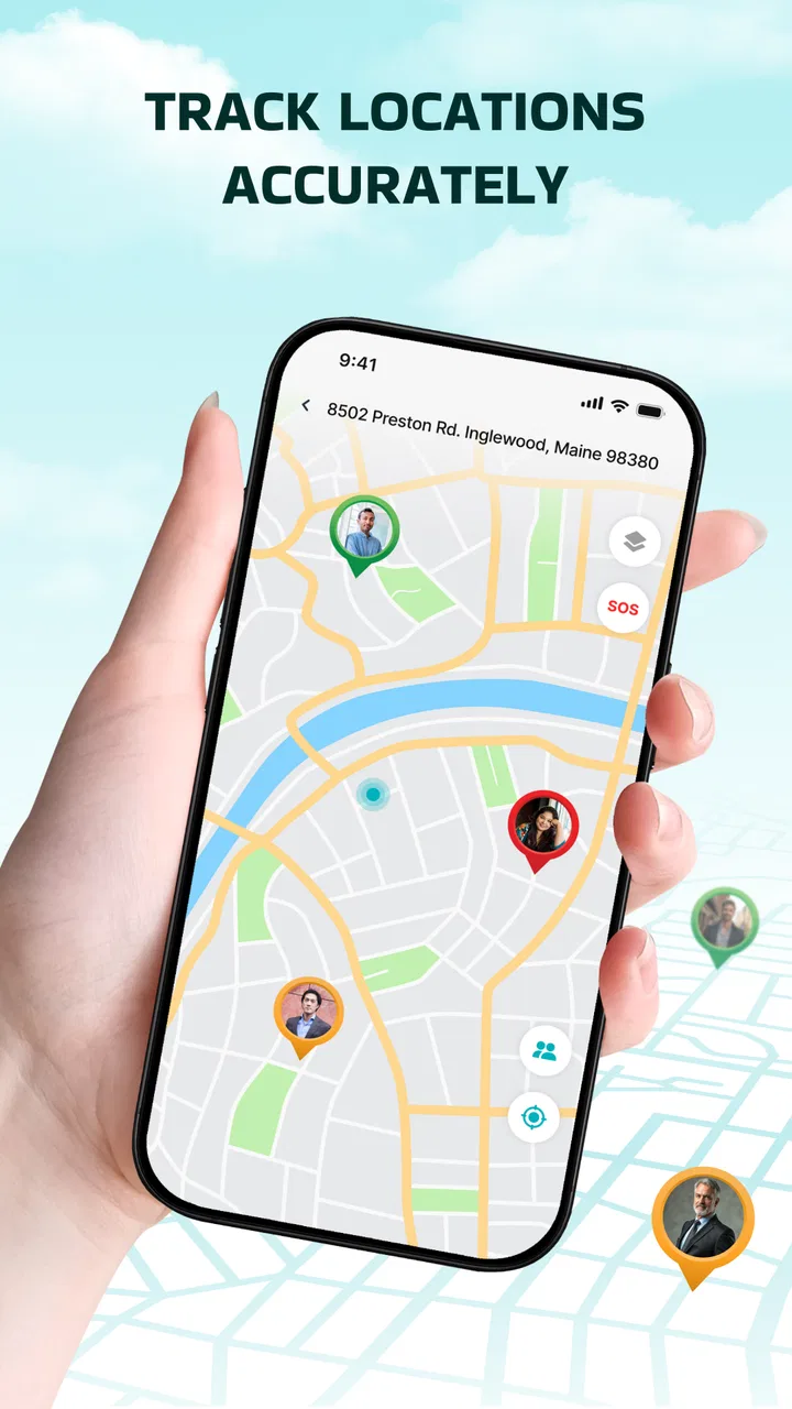
For someone who reads maps comfortably, the basic idea should be familiar. A map gives spatial context that a written address does not: whether a person is near the meeting point, moving away from it, or on the opposite side of a neighborhood. That visual context can reduce back-and-forth messages. In my view, the most useful workflow is to agree on the purpose before opening the app. For example, if I am meeting a friend, I would decide whether we are using the location only to find each other or also to coordinate a route. That prevents me from treating a tracker as if it were a turn-by-turn guide.
Readability is not only about the size of words. Maps contain roads, labels, markers, boundaries, and changing visual detail. A person with low vision may find a dense map tiring even when the surrounding controls are understandable. A person with color-vision differences may also have difficulty if important states rely mainly on color. Since I cannot responsibly promise a particular text-size system, screen-reader behavior, contrast mode, or map style, I would test the app on the intended phone before depending on it for someone who needs strong visual assistance. The practical accessibility question is whether the location can be understood quickly on your own device.
That test is worth doing with the actual people who will use the app. Ask them to open a location, identify the relevant marker, and return to the information they need without coaching. If they hesitate, the problem may not be their ability; it may be that a live map is simply a demanding format. In that case, pairing the app with a phone call or a plain-language description can make the workflow more inclusive. The map should support communication, not become the only channel.
There is also an important difference between seeing a marker and understanding what it means. A location display can show where a phone is, but that does not automatically explain whether the person is safe, whether the device is being carried, or whether the signal reflects the latest movement. I would avoid making decisions from a single glance. In an everyday check-in, I would compare the displayed position with the agreed plan and contact the person if the result seems unexpected.
Making the map easier for different readers
A useful habit is to prepare the viewing environment before a journey. Increase the phone’s system text size if that improves surrounding labels, clean the screen, and avoid checking the map in direct glare. If a user has difficulty distinguishing small markers, a companion can help interpret the screen while the user remains the decision-maker. This is not a special feature of the app; it is a sensible way to reduce the visual demands of map-based tracking.
I would also use a consistent naming routine in conversations. Instead of asking a family member to interpret a complicated map, I might say, “Tell me whether the marker is near the station or the park.” Landmarks are often easier to process than a cluster of streets. For a person with cognitive or attention-related needs, one agreed landmark and one clear question can be more useful than repeatedly zooming and panning.
That is one of the app’s trade-offs. A visual location tool can be faster than exchanging addresses, but it can also create uncertainty when the map is crowded or the user is unfamiliar with the area. People who prefer spoken directions, large textual summaries, or structured step-by-step guidance may feel more comfortable with a navigation app designed specifically for those tasks. I see this tracker as a focused visual aid, not a universal answer to every way of understanding place.
Motor, sensory, and situational use
Motor access deserves attention because location checks often happen while someone is walking, carrying bags, using a mobility aid, or riding in a vehicle. A small target or a sequence of precise taps can be frustrating in those moments. I would set up the app before leaving rather than trying to learn it while moving. That simple change reduces the need for repeated interaction and makes the experience safer for anyone who finds fine touch gestures difficult.
For a user with tremors, limited reach, or one-handed use, the best workflow may be to have a trusted person help with initial setup and then keep the later checks simple. I would avoid handing the phone back and forth in a busy street. If the app requires frequent map manipulation for the situation at hand, a different solution, such as a phone call supported by a known landmark, may be less demanding. The point is not to force every user into the map interface when a lower-effort method communicates the same information.
Sensory context changes the experience too. A bright screen can be uncomfortable at night, while a dim screen can be hard to read outdoors. Traffic noise, crowds, fatigue, and anxiety all reduce the attention available for interpreting a map. Someone who is lost may not be able to distinguish a subtle marker from background details. I would use the app in a quiet place when possible, enlarge the relevant area with deliberate gestures, and confirm the result verbally rather than assuming the visual display was understood.
For people with hearing loss, a location app can be useful because the central information is visual rather than dependent on hearing a spoken instruction. However, that does not mean the entire experience is automatically accessible. A user may still need a clear way to know when information has updated or when another person has responded. I would keep an alternative text-based or visual communication method available. The app can reduce reliance on voice, but it should not be treated as a complete communication system.
For people with cognitive disabilities, memory difficulties, or high stress, predictability matters. I recommend agreeing beforehand on what the tracker is for, who will check it, and what action follows an unexpected location. A simple plan such as “check the map once, then call” is easier to follow than an open-ended instruction to monitor someone continuously. This is a concrete strength of a focused tracker: it can fit into a short routine. Its limitation is that the routine has to be designed by the people using it.
A realistic day-to-day example
Imagine I am meeting a friend who has difficulty describing streets and does not want to make a voice call in a noisy station. Before the meeting, we agree that the app will help us identify which side of the station each person is near. I open the tracker, look for the relevant location, and use nearby landmarks to describe the next step in plain language. If the map is too visually busy, I stop trying to solve everything through the screen and send a short message such as “I am beside the main entrance.” The app helps us narrow the search, while the message removes ambiguity.
This scenario shows why I would not use a live tracker as a substitute for consent or conversation. A displayed phone position is useful only when the people involved understand the arrangement. It is also not a guarantee that the person is looking at the screen, carrying the phone, or able to respond. For a vulnerable user, a trusted contact should know the backup plan instead of assuming that the map alone provides protection.
Another practical situation is helping a family member who regularly misplaces a phone. A locator can be more useful than asking them to remember an address, especially if the device is somewhere familiar. I would still start with nearby possibilities and direct communication, because a map position may point to a building or area rather than the exact place where the phone can be found. The app can narrow the search; it cannot replace checking rooms, asking permission, or respecting another person’s privacy.
Where it fits beside familiar alternatives
Compared with a standard navigation app, this product has a narrower job. Navigation apps are usually better when I need a route, travel time, road guidance, or walking instructions. Live GPS Tracker - Locator makes more sense when the question is about a person’s or phone’s position rather than how to get somewhere. If my main problem is reaching a destination, I would choose a dedicated navigation tool. If my main problem is coordinating with someone already on the move, this focused approach may be more appropriate.
Compared with ordinary messaging, a map can reduce the need to describe every turn. That is helpful when two people are moving through the same area. Messaging remains better for context, consent, and exceptions: “I stopped at the pharmacy,” “my battery is low,” or “I cannot safely look at the screen.” I would combine the two rather than expecting a location marker to explain a person’s circumstances.
Compared with a broader family-safety platform, the appeal here is simplicity of purpose. A larger service may offer more layers of communication or monitoring, but those layers can also increase learning time and visual clutter. I would choose this app for a person who wants a direct tracking tool and is comfortable validating the workflow personally. I would look elsewhere if my household needs a mature set of accessibility controls, detailed alerts, or a highly structured support system.
Remaining barriers and responsible use
Privacy is the first barrier I would discuss before installation. Tracking friends and loved ones safely requires clear agreement about who can see a location and why. I would never treat the app as a way to monitor someone secretly. A good arrangement includes permission, a defined purpose, and a decision about when tracking should stop. This is especially important for children, older adults, people with disabilities, and anyone in a dependent relationship, because convenience can easily become pressure.
Battery life, connectivity, and phone handling can also affect any live location workflow. A tracker is not a magic window into a person’s situation. If the phone is switched off, left behind, inaccessible, or unable to provide a useful position, the map may not answer the question I have. I would therefore keep a backup contact method and avoid promising a family member that the app alone will guarantee a timely response.
The app is free, which removes a direct price barrier for trying it. It is rated for Everyone, and it runs on Android with a minimum operating system of 10. Those details make it approachable for many current devices, but they do not tell me whether every person will find the interface comfortable. I would still check the intended phone, especially if it uses an older display, unusual system settings, or assistive technology.
Its release on November 24, 2025, and current version 1.0.2 suggest a relatively early product stage. I would keep expectations practical rather than assuming the refinement of a long-established navigation service. Early versions can be perfectly useful for a simple task, but I prefer to test the complete workflow with a trusted person before using it during travel, medical appointments, or situations where a missed check-in could cause serious concern.
The app has more than a hundred thousand installs, while its average rating is currently zero. I would not read that rating as a verdict on the experience by itself, but I would treat it as a reason to evaluate the app directly instead of relying on social proof. Install it on the phone that will actually be used, try a controlled location check, and see whether both people understand the result. That small trial is more informative than assuming popularity or a rating guarantees suitability.
One subtle limitation is the difference between accessibility and availability. Because the app is free and intended for everyone, it may be easy to obtain, but an accessible experience also depends on the phone’s screen, operating-system settings, map readability, motor control, and the user’s ability to interpret location information. I would judge the whole setup. A person who cannot comfortably read the marker may need a companion workflow, while a person who cannot safely touch the screen may need another communication route.
I would also avoid using it as an emergency service unless the people involved have tested exactly what happens in their environment. A tracker can support a safety plan, but it should not replace emergency contacts or professional assistance. If someone is in immediate danger, the priority is direct help through the appropriate local service. The app belongs in the preparation and coordination part of a plan, not as its only safeguard.
My inclusive verdict
After looking at it through the needs of different users, I see Live GPS Tracker - Locator as a straightforward option for people who want a focused way to coordinate around a live phone location. I like the idea of using it to reduce vague directions, support a meeting, or narrow the search for a misplaced device. Its strongest quality is its clear purpose: it is about location, not an overloaded collection of unrelated tools.
I would recommend it to a friend who is comfortable with maps, wants a free tracking app, and is willing to agree on a respectful workflow with the people involved. It can also be useful for households that combine visual checking with messages or calls. For a user with low vision, reduced dexterity, cognitive fatigue, or sensory sensitivity, I would recommend a hands-on trial with the actual phone and a trusted helper before depending on it. The right question is not whether the app is labeled for everyone, but whether this person can use it reliably in the conditions that matter.
I would skip it when the main need is turn-by-turn navigation, detailed emergency support, advanced accessibility controls, or a complete family-management platform. In those cases, a dedicated alternative may offer a better match. I would also skip it as a secret monitoring tool; responsible location sharing must be voluntary and understood.
My final view is cautiously positive. The app has a useful, specific role, and its free access makes a practical trial easy. At the same time, a live map is not automatically readable, simple, or safe for every situation. Prepare the workflow, test it with the intended users, keep a backup communication method, and treat the location as helpful context rather than absolute proof. Used that way, this small tracking tool can make everyday coordination easier without pretending to solve every accessibility or safety challenge.
FAQs for Live GPS Tracker - Locator
01What features does Live GPS Tracker - Locator offer?
Live GPS Tracker - Locator provides real-time location tracking, allowing you to see the precise whereabouts of your family and friends. It also offers location history, geofencing alerts, and the ability to share your own location. The app is designed for both personal and family use, ensuring safety and peace of mind.
02Is Live GPS Tracker - Locator secure and private?
Yes, the app prioritizes user privacy and security. It uses encrypted channels for data transmission and requires consent before sharing your location. Users can control who sees their location and when, ensuring that your personal data remains confidential and accessible only to trusted individuals.
03How accurate is the location tracking in the app?
Live GPS Tracker - Locator provides highly accurate location data by utilizing GPS, Wi-Fi, and cellular networks. However, accuracy can vary based on environmental factors such as obstruction by buildings or weather conditions. Generally, the app maintains a high level of precision for urban and rural settings alike.
04Does the app consume a lot of battery power?
While continuous GPS tracking can be demanding on battery life, Live GPS Tracker - Locator is optimized to minimize power usage. It uses intelligent algorithms to balance tracking accuracy with battery efficiency. Users can also adjust settings to further conserve battery, such as reducing update frequency.
05Can I use the app internationally?
Yes, Live GPS Tracker - Locator can be used globally. It supports international roaming and can track locations in different countries, provided there is GPS and internet connectivity available. However, users should be aware of potential data roaming charges imposed by their mobile service providers.
Pros
- Real-time location sharing enhances safety.
- Easy-to-use interface with intuitive navigation.
- Battery-efficient
- minimizing power consumption.
- Supports group tracking for family and friends.
- Works seamlessly across Android and iOS devices.
Cons
- Requires constant internet connection.
- Privacy concerns with continuous location sharing.
- User interface lacks customization options.
- Ads can be intrusive for free users.
- Limited offline functionality.

Live GPS Tracker - Locator
Gallery